
Four systems, one platform: modernising LASSI for Victoria’s land and surveying users
09 October 2026
Overview
LASSI (Land and Survey Spatial Information) is a Department of Transport and Planning (DTP) system, that supports access to Victoria’s land, place and surveying information. Secure Electronic Registries Victoria (SERV) operates and maintains the system on behalf of the State.
Used by surveyors, councils, developers, government agencies, naming officers and other registered users, LASSI plays an important role in how land and surveying information is accessed and used across Victoria.
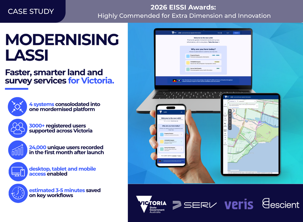
A new, completely redeveloped LASSI went live in February 2026. Delivered through collaboration between the Department of Transport and Planning (DTP), SERV, Escient, and Veris, the project brought four systems — LASSI, LASSI-SPEAR, SMES and VICNAMES — into one modernised web platform (see glossary of terms below).
The Challenge
LASSI’s functions are essential to the property sector, but the technology experience had become fragmented.
Users were working across multiple legacy systems with different access points, interfaces and support pathways. For surveyors and field-based users, limited mobile readiness created friction when accessing information outside the office.
The challenge was to modernise this critical DTP-owned, SERV-operated platform without disrupting the information, permissions and workflows users trust.
The Solution
The solution was to bring four systems into one modern, user-friendly platform and reduce fragmentation while keeping the core LASSI experience familiar.
The new platform works more consistently across desktop, tablet and mobile. It improves login, onboarding, search, mapping, workflow clarity and support. A new self-help Wiki gives users one place for guidance, step-by-step instructions and troubleshooting.
Behind the scenes, LASSI now runs on a modern cloud-native platform designed to improve performance, stability and reliability, creating a stronger foundation for ongoing improvement.
The Result
The modernised LASSI gives Victoria’s land, place and surveying users a simpler, more stable and future-ready platform.
It supports more than 3,000 registered users across Victoria, improves mobile access and preserves the familiar data, permissions and core tasks users already know.
Beyond the immediate service improvements, the modernisation reflects a broader investment by SERV and the State in the technology foundations that support Victoria’s land administration and property information systems.
For users, the change is practical: a more consistent experience across devices, clearer support, smoother access and a stronger platform for future improvements.
Recognition
The LASSI Modernisation project received a Highly Commended Award in the Extra Dimension and Innovation category at the 2026 Excellence in Surveying and Spatial Information (EISSI) Awards, recognising the collaborative effort behind the modernisation.
What’s next?
With the new LASSI now live, SERV’s modernisation focus shifts to LANDATA®.
The next phase of SERV and the State’s broader investment will continue strengthening the platforms and front-end services customers rely on every day – improving customer experience, supporting trusted access to property information and building more reliable, future-ready services for Victoria.
Quotes
“LASSI supports important land, place and surveying functions across Victoria. This modernisation helps ensure the system can continue to serve the people who depend on it, while preserving the trusted information and workflows that sit at its core.”
Noel Taylor, Head, Land Services Victoria
“This project brought together multiple systems, organisations and user needs. As project delivery lead, Escient’s role was to keep delivery coordinated across DTP, SERV and Veris, manage the dependencies between all systems and help the team stay focused on practical improvements for LASSI users. Modernising a system this critical takes careful planning and close collaboration, and that is what the team delivered.”
Andrew Faber, CEO SERV
“This project brought together multiple systems, organisations and user needs. As project delivery lead, Escient’s role was to keep delivery coordinated across DTP, SERV and Veris, manage the dependencies between all systems and help the team stay focused on practical improvements for LASSI users. Modernising a system this critical takes careful planning and close collaboration, and that is what the team delivered.”
Sophie Dodd, Consulting Director Melbourne, Escient
“As Veris, and formerly Spatial Vision, we were excited and proud to partner with Escient, SERV and LSV to modernise this important system for Victoria. As a company working across the property, surveying and spatial technology areas, we appreciate the value that can be unlocked with modern, integrated and easy to use platforms.”
Ian Miller, Principal Consultant, Veris
Glossary
Land and Survey Spatial Information (LASSI) is a free, web-based mapping platform provided by the Victorian Government. It allows surveyors, government agencies, and the public to easily search, view, and export authoritative data on Crown and freehold land parcels, survey marks, and official geographic place names across Victoria.
LANDATA® is Victoria’s online land title and property information service. It provides access to property information held in the Victorian Register of land.
Surveying and Planning through Electronic Applications and Referrals (SPEAR) is an online system that allows subdivision planning permits, certification applications and other land administration dealings to be compiled, lodged, managed, referred, approved and tracked online. Complete end to end workflows are built into SPEAR allowing applications to be lodged online with Land Services Victoria for registration.
Survey Marks Enquiry Service (SMES) (now part of LASSI) is an open-access database of all survey control mark information in Victoria. It includes options to search and download, as well as the ability to lodge new information or amendments.
ViCNAMES (now part of LASSI) is the centralised portal which enables anyone to search for all official place names in Victoria. It holds more than 200,000 road and 45,000 place names.